
![[Open Data]](https://assets.okfn.org/images/ok_buttons/od_80x15_blue.png)
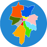
Livello cartografico contenente la suddivisione del territorio comunale nei 13 quartieri: Parma Centro, Oltretorrente, Molinetto, Pablo, Golese, San Pancrazio, San Leonardo, Cortile San Martino, Lubiana, San Lazzaro, Cittadella, Montanara, Vigatto.
Data and Resources
| Field | Value |
|---|---|
| Publisher | |
| Modified | 2023-07-24 |
| Release Date | 2021-11-12 |
| Frequency | Irregularly |
| Identifier | 026c3841-b2e2-499a-87e4-e262daad3789 |
| Spatial / Geographical Coverage Area | POLYGON ((10.121154785156 44.601590632245, 10.121154785156 44.97584949604, 10.563354492188 44.97584949604, 10.563354492188 44.601590632245)) |
| License | |
| Public Access Level | Public |